What is the City Center Master Plan?The last Birmingham City Center Master Plan Update was completed in 2004. Since then, the City Center has come a long way in a short period of time and grows stronger and more vibrant with investments large and small—from Railroad Park and Regions Field to mixed-use developments in Parkside to renovations of historic buildings like the Pizitz and the Empire buildings. Committed public and private partners and a few strategic investments have had a stunning, transformative impact on downtown Birmingham over the last two decades. Given this progress it is an opportune time to develop a new Birmingham City Center Master Plan to complement the city center’s revitalization efforts and help residents, workers and visitors to experience all that downtown Birmingham has to offer.
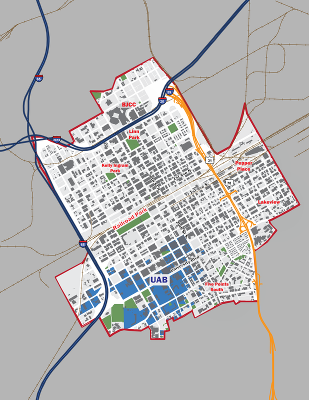
The City Center Master Plan boundary is outlined in the study area map to the right. It is generally bounded by I-65 to the west and U.S. 31 / Elton B. Stephens Expressway to the east. The northern boundary includes the Birmingham Jefferson Civic Center, Uptown District and 11th and 12th Avenues North. The southern boundary encompasses the University of Alabama at Birmingham (UAB) campus, Five Points South and the St. Vincent’s Hospital campus. Two areas extend beyond the U.S. 31 / Elton B. Stephens Expressway to the east: the Sloss Furnaces Historic Site and the Lakeview District. The western boundary includes the former Trinity Steel site (27 acres), which extends beyond I-65 near UAB. The Birmingham City Center Master Plan is comprehensive in scope incorporating elements of land use, zoning, urban design, parking, and strategic planning into a coordinated vision and implementation program and it identifies short, medium and long term projects for public and private investment in the City Center for the next 10-15 years. The plan was guided by a detailed market analysis that examined retail, residential, office and industrial trends and that establish future market demand. The plan also focuses on furthering the development of the sub-districts within the heart of the City Center, such as the Birmingham Civil Rights District, the Innovation District, Five Points, and address potential new redevelopment areas. Plan SponsorsThis Master Plan was a cooperative effort between the City of Birmingham , the Regional Planning Commission of Greater Birmingham (RPCGB) and REV Birmingham, who contracted with the Stantec Urban Places Team. Sub-consultants to the Stantec team included: W-ZHA, Zimmerman / Volk Associates, the KPS Group and Studio 2H Design.
Proper downtown development requires a tremendous amount of staff technical capacity, deal-making savvy, community support and political will to execute well. To add an extra layer of difficulty, downtown development is very visible, which means these projects entail more political risk and require bolder (and more informed) leadership from public officials " |
Study Area MapThe City Center Study Area is comprised of approximately 2,550 acres (or 3.98 square miles). Click on the map below to view or download it.
|


